


The purpose of TraceMap is to help users recall exactly where they have recently been. There are numerous examples of why people may want to do this, a few of which are listed below.
1. A user is shopping in town and has forgotten in which car park they parked their car. The user now wishes to return to their car. The user looks at the TraceMap display and scrolls back in time using the time control to the time they arrived if they can remember this, or to the obvious change between in detail between the car trace and the walking trace. They can now retrace their steps to find their car.
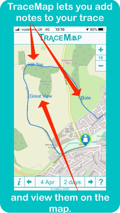
2. A user is visiting a large town that is new to them. During the day whilst exploring the town, they notice several restaurants that they would consider eating at, that evening. However they have not decided yet where they are going to stay the night. At each restaurant they add a note to their TraceMap trace. Later on in the day when they have found somewhere to stay the night, they look back at their TraceMap trace of the day to find the closest restaurant of those they found earlier, to their lodgings and use TraceMap to see how to get there.
3. A security firm is concerned that their night watchmen are not actually fully patrolling the extents of their large site. They ask their staff to install TraceMap and each morning they ask the night watchman going off shift to take a screenshot of his TraceMap trace for each 2-hour period of the night and email it to them to prove they were doing what they were employed to do.
4. A naturalist has accepted a task to monitor a large local wooded area for a species of bird that is in decline. They install TraceMap to help them record their monitoring and to ensure they actually visit all sections of the wood on a regular basis. They also decide to use the TraceMap notes facility to record the locations of their sightings of that bird, stating whether the bird was seen or just heard and whether it was also a nest site.
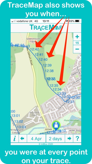
5. A cyclist is training for an upcoming race and has chosen a daily training route that is a combination of flat sections and hilly sections. They install TraceMap on their phone and after each training session they use the TraceMap timings feature to see how their performance is improving from day to day by comparing the time they have taken on each flat section and each hilly section with those the previous day.
6. A tourist visiting a foreign country has been asked to give a presentation to their local travel group, after they return home. They install TraceMap to trace their movements whilst abroad and in order to add more interest to their talk they add a TraceMap screenshot of each day’s travels into each daily section of their presentation slides which also helps as a reminder of what they did, when they actually present their talk.
7. A family is out walking in a wooded area with many different paths and as they know the general direction they need to travel they have not paid that much attention to their actual route. After a while the youngest child starts crying and says they have dropped their favourite teddy bear. The father takes out his phone that has TraceMap running on and uses the displayed trace to retrace the family’s actual steps to find the missing bear.
8. Later on, whilst still walking, this same family meet a man who is quite lost and needs to get back to the same car park that the family started their walk from. The father takes out TraceMap again and this time he uses it to explain the route they took from the car park to where they are now. He also decides to take a screenshot of the TraceMap display and send it to the man who despite not having TraceMap on his phone (yet) can look at it to see where he needs to go.